Wingtra 2.7 update brings first-ever smart RTH and more

Wingtra is regularly updating the capabilities of its premiere WingtraOne platform. This is evident in frequent, free software updates. But there’s something groundbreaking about 2.7 we really want to share with you. We sat down with Julian Surber, product manager at Wingtra, to discuss why the 2.7 software update is such a breakthrough for safety, ease-of-use and reliability.
Q: What are the key updates with 2.7 that current and potential users should know about?
A: A more precise geofence setup based on a polygon instead of a circular area; new return-to-home (RTH) logic that makes the system even more autonomous and is completely novel in the industry; remote ID, more efficient battery swap and resume, and more features.
With all of these updates, plus a simplified min and max height logic, the system offers peace of mind that you are always within a set airspace. All of this while keeping it super easy to set up and fly.

Wingtra software update 2.7 allows customers to confine their airspace with a polygonal geofence and two simple safety parameters—a minimum and a maximum height above ground. Given these settings, WingtraPilot ensures flight within a specified airspace, including during RTH.
Q: Why did Wingtra choose these updates in particular?
A: We see that businesses really need aerial data now. And more than anything else, they need it from a reliable, safe drone that is easy to use and delivers it worry-free with every flight. So this update makes absolutely sure that we cover all the features that deliver on those needs.
Specifically, we see that to integrate drones into workflows and train confident pilots fast, customers need an autonomous platform that is as easy to use as possible while ensuring maximum safety. This is all in support of state-of-the-art data capture.
If these needs are not met, any other features will not be as beneficial. So with 2.7, we are not only cementing these things, but we have also pioneered a level of autonomy that removes even more customer guesswork and human error potential.
Q: Because drone tech is always evolving, customers have the tough task of sorting through features and updates when they decide what to buy. What is it about the latest 2.7 software update, generally, that contributes to WingtraOne standing out as a leading commercial drone on the market?
A: It’s our constant goal to offer customers a product that inspires trust and cuts their overhead from the very first moment they unbox it. To do this, we keep in touch with customers and approach R&D with their core needs in mind: data quality, efficiency and ease of use.
Software release 2.7 builds exactly on this approach. With it, we make sure that customers can focus on whatever mapping job they take on while WingtraOne takes care of data capture and safety.
In fact, 2.7 makes our drone an exception to the other mapping drones out there, because this level of commercial UAV autonomy is brand new across the entire industry. Customers no longer have to set values or try to gauge their surroundings for straight-line RTH, which involves risks via human error. Instead, based on smart algorithms, WingtraOne will “choose” an RTH route that keeps it safe and brings it home in the most efficient way, every time, no matter the complexity of the terrain.
Q: Everyone is concerned about efficiency, so the old approach of a direct line back to home seems like a clearly efficient way to RTH—why overhaul it? What problems does this solve?
A: Remember, Wingtra is headquartered in Switzerland, where the terrain is the most complex imaginable. Our engineers spend all their free time looking at it, and it informs the decisions we make about what our drone needs to account for to perform in the most effective and safe way possible.
That said, imagine your flight involves some big changes in elevation across the plan. The drone’s flight lines follow the terrain, so if it is lower than at the start, do you want to risk that your straight-line RTH flight height is possibly too low for a forgotten peak between the end of the mission and the home point? People have, and it has cost them dearly. We don’t want people to go through this.
Anyone who has would agree that a slightly different route home—decided by a drone that factors and calculates everything that worked in the mission to that point—would be a great feature!
In fact, what we have seen in extensive testing of this feature is that the efficiency of the RTH is identical for the majority of flights. Only for a small fraction of flights is it reduced. And in the worst case this is only by a couple of minutes. It’s a small sacrifice for complete peace of mind that your drone lands without any unfortunate incidents.
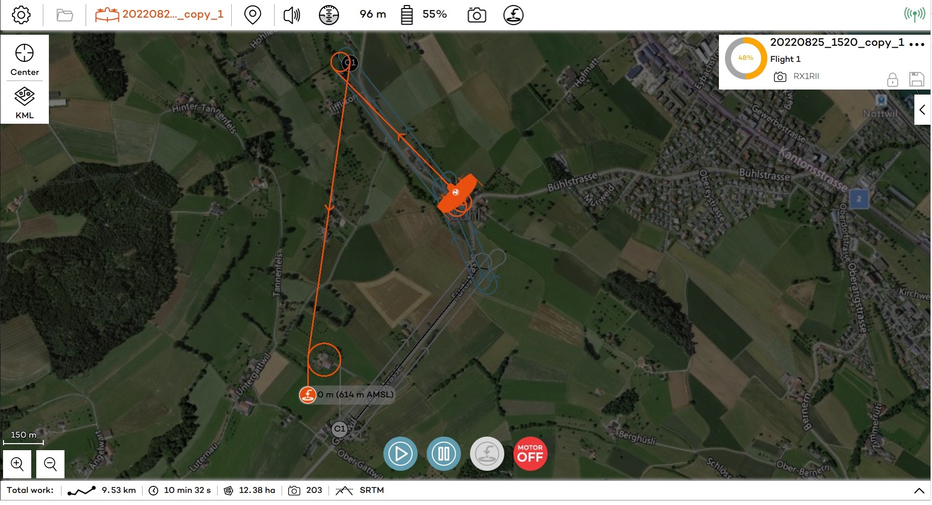
With the 2.7 software update, WingtraOne will now RTH on an energy-efficient path that is safe against terrain collision. To do this, it will reuse elements of the flight plan instead of returning on a straight line.
Q: What are the key factors that the drone weighs when “deciding” on the best path home?
A: After you’ve entered a flight plan and before you take off, WingtraOne uses the terrain information and the flight plan itself to calculate a number of return-to-home options. Once it’s in the air, it decides the most efficient one based on its exact location at the time plus wind direction, wind magnitude and several other factors.
Q: You said this RTH feature is a first in the industry, have you seen anything like this in other drones?
A: No. We are again pushing the industry forward with this software update. The aim is full autonomy. In fact, a drone is an aerial robot that will know best what it has to do to fly safely.
Q: How does the polygonal geofence eliminate challenges and update the experience with WingtraOne for mapping missions?
A: Let’s say you are flying near Native American lands, national parks, FAA administered airfields—do you want to risk overlapping any part of these areas with a mission? The circular geofence risks this if your mapping area is complex. So this new feature allows you to create a snug-fitting area around your mapping area that prevents any trespassing, even during the intelligent RTH.
Q: You mentioned an efficiency boost due to an improved battery swap and resume—can you explain what changed?
A: People generally recognize WingtraOne for its broad coverage ability at this point, but they may not know how this extends beyond just one flight. In fact, customers can design massive flight plans over many kilometers and simply swap batteries on landing and send the drone back up in a matter of two minutes. You can be flying all day long with our swap and resume feature, which is all but effortless!
The one thing that we wanted to robustify about this continuous mapping ability is the resume in cases of long areas. Before, the drone would restart the last sweep, including data capture. If the sweep was long, this meant unneeded data capture, which slowed down field and processing workflows. Now, when you resume, WingtraOne goes right back to where it captured the last data points and continues.

With the 2.7 software release, WingtraOne broadcasts remote ID in accordance with upcoming regulations.
Q: Why is remote ID important, and where is Wingtra in developing this according to regulations?
A: This industry started 10 years ago and was a bit of a wild west in terms of rules. But just like with cars, the regulations are increasing and becoming more specific so that it can go mainstream and be as safe and effective as possible.
As we create a need for a leading drone platform that allows customers to stretch the limits of surveying and mapping, it’s really our responsibility to ensure that customers can use it without any interruption. It’s also up to us to reassure corporations and governments that we are on board with keeping airspaces safe.
As a reminder to anyone, remote ID will be required to fly drones in the US and Europe in the near future. Specifically, in the US, from September 2023 operators will only be allowed to fly aircraft that have this feature, and drone manufacturers must be compliant as of now. In the EU, we have until January 2024, then all pilots will be permitted to fly with remote ID aircraft only.
Q: Any other insights you think are important for customers to know right now?
A: I guess I’d just like to say that we pay very close attention to our current customers and the needs of the market. We go into the field with them. We have a feedback community. So we see their challenges first-hand. That said, we not only work to keep our solution a step ahead, but we also develop products like extended services, which help protect customers from unexpected expenses and integrate our drone into budgets over the long run.
And we are constantly researching and working with drone processing software and fleet management software companies to ensure smooth compatibility as this data becomes a matter of fact across all industries.
Without satisfied customers, we know we would not have come this far, and we plan to go many times further on that foundation.
Wingtra software release 2.7 is available for download now.
For more information about how WingtraOne can impact your business, peruse our website at: wingtra.com.
To start a detailed conversation about demos, rentals and purchase with a dealer near you, visit: wingtra.com/talk-to-sales


