Altitude Angel adds UK Prisions to it’s database.

Working with HM Prison Service, we are pleased to announce the general availability of our UK Prisons datasets to our apps, maps and developer platform APIs. This means it is now easy for drone pilots to identify prisons and other HM Prisons facilities. Connected drones and flight planning apps using our geofencing platform will automatically receive the new areas and help you avoid them.
It may come as a surprise, however, only a few prisons in the United Kingdom are actually covered by specific regions of regulated airspace which would prohibit flight over them. Other than conditions otherwise stipulated within the Air Navigation Order, this means there are no specific aerial restrictions in force. In addition, as many UK prisons are located within relatively dense urban environments, creating ‘arbitrary’ circular restricted areas over them would potentially impact those flying legally nearby, caught up in the catchment area of the circle.
Introducing Prison Land Boundaries
To help you identify UK prisons, we have taken the land boundary of the prison and inflated it by 50 metres – the distance the Air Navigation Order requires you to keep from buildings or structures that are not under your control (of course, if you are a licensed commercial drone pilot and you do have such permission, you will be able to ‘filter’ the prison zones from view).
The example shows a UK prison overlaid on to our Ordnance Survey base map – a really popular choice for those flying in the UK:
Clicking on the prison will yield further guidance:
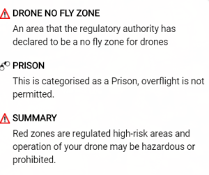
Note: we have listed all HM Prisons (and related facilities) as ‘red zones’ on our map, to indicate that the area is a ‘high risk’ zone, and that flight of your drone might be hazardous and/or prohibited.


