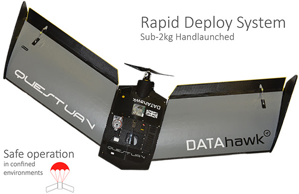
QuestUAV DATAhawk

Inspired by survey professionals, the DATAhawk is a fully autonomous superior mapping drone from QuestUAV. Easy acquistion of accurate geodata for survey mapping and GIS professionals. Automatically convert your high-res data into geo-referenced 2D orthomosiacs, 3D models and point clouds giving fast and reliable results… every flight.
Easy
Operations:
A ruggedised transportable design sets a new standard for high reliability fixed wing mapping drones. The high performance DATAhawk includes state-of-the-art, intuitive flight planning and mission control software giving ease of use and total control of your mission, from flight to data output.Example Easy Launch
Reliable
Results:
The turnkey DATAhawk solution includes advanced photogrammetry software, powered by Pix4D Mapper, to turn images into professional orthomosaics, point clouds, including in-field data preview functionality.
Efficient
Specifications:
* Rugged Airframe
* All-season
* Hand-launched
* Para-Landing
* 18MP camera (std)
* 20.1MP gimballed (opt)
* 65km/h wind resistance
* Upto 1.5cm GSD
* Upto 20km2 coverage
* 1hr endurance
* VLOS/BLOS/30Km range
* Sub 2kg weight
* 115cm Wingspan
* Up to 100km/h cruising speed


