Earth Science and Climate Monitoring | NASA Using Unmanned Aerial Vehicles To Eye Hurricane Power

By Debra Werner
SAN FRANCISCO — In August, NASA plans to begin flying two Global Hawk unmanned aircraft in an intensive campaign to gain insight into the dynamics of hurricane intensity change in the Atlantic Ocean basin.
“We are pretty good about predicting the track of a hurricane,” said Marilyn Vasques, program manager for the Hurricane and Severe Storm Sentinel (HS3) at the NASA Ames Research Center in Moffett Field, Calif. Meteorologists are less adept, however, at determining whether a storm is likely to intensify.
“The most difficult thing we face as forecasters is understanding whether a storm will change from a Category 1 storm to a Category 3 storm suddenly, slowly or not at all,” said Jeffrey Halverson, a co-investigator on the HS3 science team and geography professor at the University of Maryland, Baltimore County.
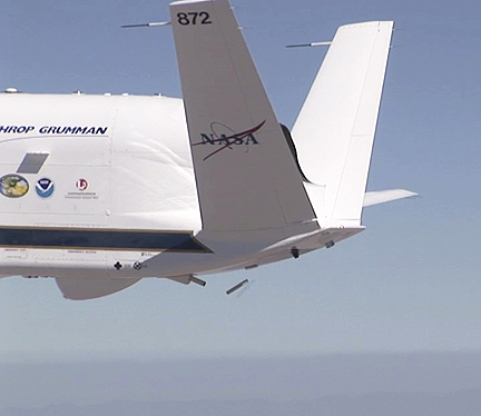
For the HS3 mission, scheduled to begin Aug. 20 and run through Sept. 23, NASA plans to fly two Global Hawks equipped with instruments to measure atmospheric humidity, pressure, temperature, aerosols and wind speed, Vasques said.
One aircraft features instruments designed to gather data while peering down through clouds and precipitation at the “guts of the storm,” said Bernadette Luna, HS3 deputy project manager at NASA Ames. That instrument suite, dubbed the Over-Storm Payload, features: a conically scanning Doppler radar, known as High-Altitude Imaging Wind and Rain Airborne Profiler; a multifrequency interferometric radiometer, called Hurricane Imaging Radiometer; and the High Altitude Monolithic Microwave integrated Circuit Sounding Radiometer.
The second HS3 aircraft is equipped with sensors to observe atmospheric conditions in the immediate vicinity of the storm. The Environmental Payload on that aircraft features: the High-resolution Interferometer Sounder to provide data on atmospheric temperature and water vapor; an airborne Doppler lidar, called Tropospheric Wind Lidar Technology Experiment; the Cloud Physics Lidar; and dropsondes, devices created by the National Center for Atmospheric Research to measure storm conditions as they fall from aircraft to the ground.


