Leica takes next step in UAS strategy: 3D inspection and mapping
Leica Geosystems Inc., the world‘s leading manufacturer of airborne mapping systems, said Thursday it signed a deal with German unmanned aerial systems (UAS) manufacturer Aibotix GmbH to create end-to-end solutions for the professional inspection and mapping market.
“For us this is really the next step in our UAS strategy,” said Rüdiger Wagner, general manager of Leica’s geospatial solutions division. “UAS-based mapping solutions are on the increase and we have been carefully expanding our exposure to this market by focusing on select applications.”
Headquartered in Heerbrugg, Switzerland, Leica is part of Sweden’s Hexagon Group and maintains U.S. headquarters in Norcross, Ga. The company also specializes in offering digital airborne and lidar sensors for the geospatial industry.
AVs are increasingly used by governments in Europe and elsewhere abroad for law enforcement, transportation, public safety, and disaster assessment. U.S. law continues to ban the use of UAVs for commercial use.
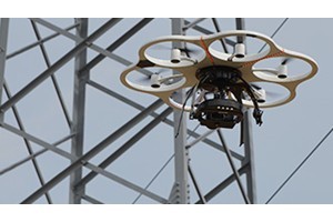
Lightweight unmanned aerial multicopter systems such as Aibotix’ X6 – with advanced, multi-sensor, intelligent guidance systems – are proving ideal for infrastructure inspections of powerlines, bridges, dams and power plants.
The X6 has a plug-and-play payload integration, fully autonomous flight planning and execution, and monitoring features to ensure safe operation, the company said.
Because of their vertical takeoff-and-landing capability and payload capacity, UAS systems represent an ideal platform for vertical and locally focused mapping tasks such as buildings and other vertical structures including rock faces.
“The Aibotix X6 multicopter was designed specifically for inspection applications in difficult areas with no piloting expertise required,” said Joerg Lamprecht, managing director at Kassell, Germany-based Aibotix, whose name joins “AI” from artificial intelligence and “BOTIX” from robotics.
UAS mapping services for inspection applications will be available from Leica starting in October. Leica’s airborne sensor portfolio includes the popular Leica RC30, the Leica RCD30 series of medium format digital frame cameras, the Leica ADS pushbroom sensors, the Leica ALS LiDAR series, and the Leica IPAS GNSS/IMU solutions.